Button CopyPathCircle CloseCircle Left ArrowArrow Down Icon GreyClosecirclecircleBurger

88 Pt Lot Highway 10, West Grey, ON, N0C 1H0

MLS® # X7261530
Vacant Land For Sale In West Grey, Ontario
$339,000
88 Pt Lot Highway 10, West Grey, ON
  • Advertising
ACTIVE
88 Pt Lot Highway 10, West Grey, ON, N0C 1H0
$339,000

Property Information:

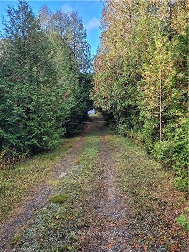
Welcome to this beautiful 10 acre piece of property just north of Markdale. Approximately 672' of frontage on Hwy 10 and backs onto 77 km of the Grey County Rail Trail running from Owen Sound to Dundalk. A wonderful place to call your country retreat perfect for relaxing and unwinding. Thick cedar bush where trails could be easily made for skiing, hiking, snowshoeing all on your own property. ATV or snowmobile out your back yard where the property boundary borders the rail trail. There is no Fire # but there is a driveway at the north end of the property. Two old storage sheds just inside the gated driveway will remain and are 'as is' 'where is'. The property is zoned Natural Environment. Buyer should verify any re-zoning changes or questions with Saugeen Valley Conservation Authority that will support the possiblity of building permissions or ideas. A lovely piece of property you'll fall in love with!

Building Features:

  • Utilities-Gas: No

Property Features:

  • Annual Tax Amount: $897
  • Acreage: 5-9.99
  • Fronting On (NSEW): W
  • Lot Depth: 719.61 Feet
  • Lot Frontage: 672.41 Feet
  • Occupancy: Vacant
  • Sewers: None
  • Utilities-Cable: Available
  • Utilities-Hydro: Available
  • Utilities-Municipal Water: No
  • Utilities-Sewers: No
  • Utilities-Telephone: Available
  • Water: None

Data provided by: Toronto Real Estate Board 1400 Don Mills Road, Toronto, Ontario M3B 3N1
All information displayed is believed to be accurate but is not guaranteed and should be independently verified. No warranties or representations are made of any kind. Copyright© 2021 All Rights Reserved

Location of 88 Pt Lot Highway 10, West Grey, ON, N0C 1H0

Climate Risk Data

About Climate Risk: Properties are at increased risk of damage from extreme weather due to climate change.
ClimateCheck provides detailed climate risk data for properties now and up to 30 years into the future.

Projected Heat Risk: Moderate

32 hot days expected in 2050

Projected Precipitation Risk: Moderate-High

15 storms expected in 2050

Projected Heat Risk: High

32 hot days expected in 2050

44/100

High

ClimateCheck®

Current data

This property, 88 Pt Lot Highway 10 , experiences 7 hot days per year at around 29.4 degrees Celsius.

Projected data

Severe heat risk is expected to increase in this area. In 2050, it is projected that there will be 32 hot days at 32.9 degrees Celsius.

Projected Avg. Temperature

Past
29.4℃
2050
32.9℃

# Hot Days Per Year

Past
7
2050
32

About Heat Risk

Heat risk is the number of extreme heat days experienced each year looking at historical conditions (1980-2005) in your area and taking the 2% of the hottest days and projecting that into the future.

Projected Precipitation Risk:

15 storms expected in 2050

72/100

ClimateCheck®

Current data

This property, 88 Pt Lot Highway 10 , experiences 12 significant 2-day storms per year, with about 335.5mm of precipitation per storm.

Projected data

Severe storms are expected to increase in this area. In 2050, it is projected that there will be 15 significant 2-day storms with 424.5mm of precipitation per year.

Precipitation Per Storm

Past
335.5mm
2050
424.5mm

48-Hour Storms Per Year

Past
12
2050
15

About Storm Risk

Storm risk is the number of high wind, wet or snowy events each year. Climate check looks at historical conditions (1980-2005) in your area, on the days with the top 1% of total precipitation in a year and projected to 2050.

Climate risk data is provided for informational purposes only on Royallepage.ca.
If you have questions or feedback about this data, get help at climatecheck.com.

Environmental Risks provided by ClimateCheck®

Royal LePage does not endorse nor guarantee this information. By providing this information, Royal LePage and its agents are not providing advice or guidance on climate risks. Royal LePage strongly recommends that consumers independently investigate the property’s climate risks to their own personal satisfaction.

Demographic Information of 88 Pt Lot Highway 10, West Grey, ON, N0C 1H0

Life Stage

Midlife Families

Employment Type

Mixed

Average Household Income

$105,308.36

Average Number of Children

1.79

Household Population

Household Structure

Age of Population

Education

Education Level

No certificate/diploma/degree

21.75 %

High school certificate or equivalent

35.53 %

Apprenticeship trade certificate/diploma

7.58 %

College/non-university certificate

27.98 %

University Degree

7.16 %

Commuter

Travel To Work

By Car

70.89 %

By Public Transit

0.0 %

By Walking

21.72 %

By Bicycle

0.0 %

By Other Methods

7.39 %

Cultural Diversity

Knowledge of Official Language

Mother Tongue

Building Information

Building Type

Apartments (Low and High Rise)

22.54 %

Houses

77.46 %

Own Vs. Rent